Thursday, 25 June 2009

Mexico City - photos 1


Mexico City: view of the city from the Torre Latinoamericana

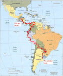
Here we are!!! Mexico City!!! 9 months after landing in Buenos Aires, we reached the last stop on our trip.

We stayed in Mexico for 1 week and half spending time visiting the city and the surroundings but also finishing to buy some presents for family and friends. Our hotel was situated in the Cuauhtemoc Colonia, close to the Hidalgo Metro station which allowed us to be pretty mobile as the Metro system in Mexico City was excellent. We used it all the time!

Mexico City Metropolitan Area has a population exceeding 22 million people. That is the third largest in the world. What was strange was the fact that the streets were quite empty and even in the Metro the wagons were not over crowded.

The "Ciudad de Mexico" was officially established in 1585. Before, in 1325, the city was an Aztec city called Tenochtitlan (and was built on a island) then known in 1524 as Mexico Tenustitlan after the Spanish conquest. Cortes, helped by the Tlaxcalan arrested first Montezuma, the Aztec chief then defeated the new chief Cuauhtemoc in 1521 after a siege of three months. Mexico City was rebuilt on the ruins of Tenochtitlan as Cortes razed the Aztec city. Due to constant flooding, during the 17th Century, the lake was filled and the water drained. The city then prospered specially due to its location close to both the Pacific and Atlantic oceans. The independence of Mexico was declared in 1824 with Mexico City being its capital.

- The Torre Latinoamericana was built in 1956 and with 183m with 45 stories, was the tallest building in Mexico City (until 1972) and at this time the tallest in Latin America. Situated in the historic center, it offered a superb panoramic view of the city...

-...and was nicely illuminated after the sunshine with a variety of colours and a lightshow. The pictures were taken from the Alameda Central and the gardens of the Palacio Bella Arte.

- The Plaza de la Constitution or Zocalo. We were surprised how far we could see over the town. We knew that Mexico City was suffering from poor air quality but that was not so bad. This picture is the best I had from the Zocalo due to the installation of white tents here for a temporary exposition. These tents were masking all the Plaza and the picture of the cathedral was only possible from the Palacio National (see next post). We can recognise on the left the cathedral, in front the Palacio National and in the center of the Plaza the impressive flag. This flag was created in 1821 when the Independence movement had ended victoriously.

- The Alameda Central was created in 1592 as a public park. It occupies now an old Aztec market place. In the left center of the park, we can distinguish the "Hemiciclo a Juarez", a semi-circular monument dedicated to Benito Juarez. Our hotel was just at the end of the park (where we can see the high buildings),

- The Palacio Bella Arte. The theater is used for classical music, opera and dance. The outside are made of italian white marble and inside the murals are from various known artists like Diego Rivera. It was built during the Presidence of Porfirio Diaz and its construction took 30 years due to various building problems and the Mexican Revolution,

- West view of Mexico City. In the background, on the left, Santa Fe. Then the Torre Mayor, the tallest tower in Mexico City. On the background right, the Torre Pemex. On the center left, the Chapultepec park.
- North view of Mexico City. On the bottom left (white roof), the Senado de la Republica with on its left, the Postal Palace and in front, the Museum National of Art.

Monday, 22 June 2009

Around Tlaxcala - photos


Around Tlaxcala: Cacaxtla and San Miguel del Milagro
Cacaxtla:
Cacaxtla was the capital of the region occuped by Olmeca-Xicalanca settlements, probably a Mayan group coming from Central Mexico as early as 400AD. After the decline of Cholula (see previous post), Cacaxtla became the chief power of the South of Tlaxcala and the Valley of Puebla. By 1000AD, the city was abandoned. The site was only discovered in 1975.

- On the way to the ruins from the entrance, we could admire this nice view of the volcano Izta (see previous post) and its glacier,
- The "Gran Basamento" or the main platform was covered by a huge metallic roof to protect the paintings. Here were located the religious and civil buildings,
- Painting from the "Vestidos de Sacerdotes" or "priestly altar". This painting represents the bird man probably a ruler-priest of the Olmecas-Xicalancas. This bird man was associated with Quetzalcoalt, the generous deity who taught people art and agriculture. These paintings are unique as they combine the symbology of Altiplano cultures and Mayan influence,
- Part of the "Batallas por el Poder" or "battle for the power" wall. These paintings have been interpreted as confrontation between the local group and one from the South of Mexico. This painting could also represent a ritual in which the conquering warriors display their arms and the conquered warriors are sacrified. The painting is made from mineral and vegetal pigments,
- Detail from the Battle Mural. The wall was protected by a glass or plexiglass so the colours are faded.
San Miguel del Milagro:

San Miguel del Milagro is a small village close to the Cacaxtla archeological site. Why this name? Well probably a relation with San Miguel Archangel? Right!
The story is that San Miguel appeared in 1631 to one of the first baptised local men and told the man the location of a water fountain which will cure all the illnesses. But sceptical, the man kept for him the apparition and 2 weeks later, he became gravely ill. San Miguel appeared again and brought the man to the fountain telling him that he had to make the fountain known or he will be badly punished. So the family of the man, which was the only persons to believe him, started digging following the advice of an supernatural light to give the exact location and the help of a young man of an extraordinary appearance to remove the heaviest stones. And appeared the fountain but the local man, by the fear of people, kept the secret for him. Six months later, he started to feel lots of pain. San Miguel appeared again accusing the man of not complying with his desire regarding the fountain. So the man went to the fountain, filled two buckets of water and gave them to the priest who forwarded the water to the hospital. All the ill persons were cured after taking the water.
And so started the pilgrimage to this little village. The fountain, in front of the church, still exists but is often closed for lack of water.

- The decorated entrance of the church,
- On a side part of the church, the statue of San Miguel is visited by pilgrims who left all sorts of clothes and objects of sick relatives around the statue.

Tlaxcala - photos 2


Tlaxcala:
- La "Plaza de Toro" or the "bull ring" was the first plaza de Toro of the continent built during the 19th Century and still in use,
- We were surprised to hear some music from the Zocalo on Friday late afternoon. Coming closer we saw lots of people from all the ages dancing to the music of the local band. Everybody was smiling and happy to show their knowledge on ballroom dances. Very nice ambiance!
- And Sunday we were also surprised to see these people playing chess on the Zocalo. The chess boards were placed here, we supposed, by the municipality and were free to be used,
- Lee tried the famous "mole poblano con pollo", chicken in a sauce called mole speciality of the nearby city of Puebla. The sauce was made of chocolate, cinnamon and nuts with various hot peppers. Lee said it was an interesting experience but will not add this dish to his most favourite meal!!! Not for my taste at all either!!

Tlaxcala - photos 1


Tlaxcala:

From Puebla, we headed off to the very quiet and peaceful Tlaxcala, our last stop before reaching Mexico City. We could have gone directly to the capital but we wanted to have a look to this not too well known city. Well to be described as quiet, the town was quiet, not sure where were the 16,000 inhabitants! We had a nice time discovering the town and visiting the ruins of Cacaxtla and what a relief...very few tourists...

Tlaxcala or Tlaxcala de Xicotencalt is the smallest capital of the smallest State in Mexico. Only around 16,000 inhabitants! And it is even not the most populous city in the State! The city was originally settled by indigenous people who fought fiercely when the Spaniards arrived in 1519 but formed an alliance with them to combat their former Aztecs oppressors (with the exception of a chief Xicotencalt the Younger who is now a Mexican hero).

- View of the town from the capilla del Cristo del Vecino. The tower which can be seen on the right of the picture belongs to the ex-convento Franciscano de la Asuncion (16th Century) and ...
-... was not built on the church building but attached to it giving a unique "touch" to this Temple. Also this church could be where the first baptisme of Native American was made by priests associated to Cortes,
- Close to the ex-convento, the "capilla" or "chapel" del Cristo del Vecino (17th Century). There were 5 others capillas dispatched all around the town,
- The Basilica and Santuario de la Virgen de Ocotlan. The Virgen de Ocotlan is the saint patron of Tlaxcala and the close State of Puebla. The legend says that the Virgen appeared here in 1541 to a young native of Tlaxcala. Since then it is an important pilgrimage site in Mexico. The church is located on a hill overlooking the city,
- The very peacefull plaza of Xicotencalt where the craft market takes place every Saturday and Sunday.

Tuesday, 16 June 2009

Around Puebla - photos


Around Puebla: Cholula

Cholula is 15Km from Puebla and hosts the Great Pyramid, the largest man-made pyramid and monument by volume in the world. The pyramid has not been fully excavated and restored because the Spaniards built in 1594 a church, the 'Iglesia de Nuestra Senora de los Remedios", which is a major Catholic pilgrimage. So the first sight of the pyramid is a natural hill with a church on the top! But inside the pyramid, 8 km of original tunnels can be visited.

- The church or Sanctuary at the top of the hill. Only on one bottom side of the hill, the remains of the pyramid can be seen,
- Lee was posing in front of the 2 volcanoes, Popocatepelt and Iztaccihualt, called by the locals Popo and Izta. Popo, on the left, is an active volcano and is the second highest peak in Mexico. Its name in Nathualt means "smoking mountain". Izta, which name means "white woman", is the third highest peak in Mexico and is constituted by 4 peaks which depict the forms of a woman. These volcanoes can be also visible from Mexico City depending on atmospheric conditions,
- View of Popo from the highest platform leading directly to the church. The fume leaving the volcano is well visible,
- View of Cholula from the Church. In the center of the picture, the ex-convento de San Gabriel.

Puebla de Los Angeles - photos 2


Puebla de Los Angeles:

- Passive protest of farmers on the Zocalo,
- Still on the Zocalo, every Thursday at around 6pm, the town band plays for hundreds of people. They were lucky this Thursday because all the rest of the week it was pouring rain at this time. But nicely, the rain waited the band to finish its recital to start,
- 20m from our hotel, we found a local Taqueria ''El Gran Taco'' which was serving the best tacos we had tried so far. The speciality was tacos with Arabe bread. On the first picture, I ordered ''tacos con carne Arrachera'', a fine beef meat. Unfortunately for me, they arrived full of raw onion and coriander and I hate coriander and raw onion. But once removed, the meat was very tasty. Lee's taco was made with beef and pork meat and as Lee says: ''it was damn tasty''. In four days, we went three times in this restaurant!!!
- How cute was this police car! We called them the ''policemobile'' {as a reference of the papamobile of course}. Very practical and ecological!

Puebla de Los Angeles - photos 1


Puebla de Los Angeles:

After Oaxaca, we headed off to the superb city of Puebla de Los Angeles which is the fourth most populous metropolitan area in Mexico. We stayed here a couples of days to visit the city, the town of Cholula and the safari zoo (no picture will be posted). It was obviously raining all the mid-afternoon or early evening.


Puebla de Los Angeles was founded in 1531 by the Spaniards and was built on the ruins of Amerindian settlements. Half way between Mexico City and Veracruz, it became the second most important city during the colonial period. Its historic centre is classified UNESCO World Heritage Site but lots of the colonial buildings were damaged during the 1999 earthquake with some of them being restored. It is surrounded by 4 volcanoes, Popocatepelt and Iztaccihualt at the West, LaMalinche at the North and Pico de Orizaba at the East.


- The cathedral of Puebla whose top appears on the 500peso notes. Its construction started in 1575 and was totally completed by 1690. It possesses the highest towers in Mexico.
- One of the sides of the Zocalo. The plaza was surrounded by arches (except the side where there was the cathedral) where cafe and restaurants were proposing the specialities of Puebla,
- Night view of the cathedral with the main plaza in front,
- The facade of this building was made with tiles of "Talavera", a fine earthenware of colonial origin and very famous around Mexico,
- I liked the facade of this building, not very colonial but more beginning of 20th Century. Remember some streets in Paris!

Monday, 15 June 2009

Around Oaxaca - photos 3


Around Oaxaca: Pueblos Mancomunados and Sierra Norte

From Oaxaca and the office of 'Expediciones Sierra Norte', we organised 2 days of hiking in the Sierra Norte, the southern part of the Sierra Juarez; one day in Llano Grande and the next day in Cuajimoloyas, village part of the Pueblos Mancomunados community or ''Commonwealth of Villages''. We spent the night in Llano Grande in a cabana which was comfortable with hot water shower and a fire place where Lee was happy to make a fire with proper wood. There was no heating system in the cabana and the night was particularly cold and rainy. The second day, the rain came late morning and instead of the 5hrs hiking, we only did 3hrs but we were quite happy because we were tired and freezing {well me anyway}. We had not done any mountain walks for a long time...our leg muscles were just not responding!!! But we had a good time and saw superb landscape and it was hard to believe that in the hot Mexico, there were typical pine forest mountains!!

- On our way to the Piedra Larga mirador, we saw hundreds of these ''mariposas'' flowers, specific for this part of the mountain,
- Lee at the top of the Piedra Larga mirador. Lots of clouds but still superb view...
- From the Mirador, we could enjoy the view of this rock formation. Can you distinguish the figure of a man?
- The second day, we went to the Piedras Coloradas Mirador which was offering a nice view of the pine tree forest. To reach this mirador, we needed to climb a steep rock formation and I can tell you I was pretty scared as I don't like heights but I managed it and I was proud of myself!
- This type of cactus is called a ''Maguey''. They produce a flower every 20 to 25 years and it takes around 1year for the flower to grow. On the left, we can see the stork of a future flower...looks a bit rude doesn't it.....

Around Oaxaca - photos 2


Around Oaxaca: Hierve El Agua

Following the recommendation of our friend Fernando, we went to visit this incredible site, Hierve El Agua. And it was amazing...

From Oaxaca, we took a bus to Mitla. Here, due to the lack of tourists {locals and foreigners}, we had difficulty to find a colectivo to bring us to Hierve. We managed to get a good price just for us and the driver waited for us for 1hr while we were visiting the site. It is nice to go to visit during the low season as there is less people around but things like transport can be a problem sometimes. When we arrived to the main site, we were surprised to see all these locals laughing and having good time around the swimming pools. The most surprising was to hear them talking the ''Zapotec'', a ancient language from the Mayan civilization. It was like being in a different country!!!

- From the car park, a little walk brought us to the main site with 2 artificial swimming pools. The water here is highly concentrated in salt making the colour turquoise green. The water is not hot but effervescence brings the water at the edge of boiling so the name of the site,
- Here is one the rock formations with the 2 swimming pools. View from the main 'waterfall',
- On our way to the main waterfall, we crossed this group of Zapotec women wearing the traditional costume. Lee was having attention from them as I am not too sure they are used to meet 'gringos' often!
- The top of the main 'waterfall'. The ambient temerature water slowly runs over the cliffs and evaporates leaving behind minerals and in particular calcium carbonate forming like a waterfall,
- The main 'waterfall' with a height of 30m. The picture was taking from the smaller waterfall,
- Side view of the waterfalls.

Around Oaxaca - photos 1


Around Oaxaca: Monte Alban and the ''Arbol de Tule''

##Monte Alban is a former capital of the Zapotec civilization founded around 500BC and was dominating much of the Oaxacan highlands. By AD500-750, the city lost it's political dominance and was thereafter abandoned. The site stands on a flattened hilltop west of Oaxaca {30min in bus}.

- Panorama of Monte Alban from the South platform. In front, the edifice J or 'observatorio' then the edifices G, H and I and on the background, the North platform,
- Panorama of the West side of the site with from front left: edifice O, system M and edifices L and N,
- Staircases of North Platform. These were forbidden to the public,
- Due to its position 400m above the valley floor, Monte Alban offered nice aerial views of the valleys,

##El Arbol del Tule is situated in the village of Tule, 10km from Oaxaca and is considered like the largest in the world. The trunk of this 'ahuehuete' or Montuzema Cypress, possesses a diameter of 14m!!! The tree is 42m high and more than 2000 years old!!! It stands close to the 17th Century Church.

- El Arbol del Tule is situated left of the church. On the right, its son,
- Lee in front if the trunk of the Tree. This Cypress looked massive!!!
- A part of the branches of the tree...amazing!