Thursday, 28 May 2009

Uxmal - photos


Uxmal:

From Merida, we took a local bus which left us at the entrance of the Mayan site. Uxmal, like all the others archeological sites in Mexico, was closed for 5 days when the federal government decided to close restaurants, cinemas, schools...to avoid the virus of the influenza AH1N1 spreading all across Mexico. The site was reopening for midday.

Uxmal, whose name means 'That which was built three times' or 'place of abundant harvest' was occupied around 500 BC but the majority of the work was done between 600-1100 AD. The pyramids and other buildings are beautifully decorated and the architecture in this region is distinct from others sites in Yucatan and is known as the 'puuc' style.

So we arrived around 1 pm and it was pretty damn hot...the site was well conserved but a little too much. The restoration gave pyramids too perfect like made for a decor in a movie. Everything was too smooth but still nice ruins and we crossed only 5 tourists.

- View of the 'pyramid of the Magician', 35m height which is still holding a large number of enigma. The last excavation showed that the pyramid was the ritual centre and residence of Chaac, the last governor of Uxmal. The architecture of this pyramid is quite unusual: the layers of the step pyramid are oval, rather than the usual rectangular or square shape.
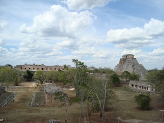
- panoramic view of the site with on the right, the pyramid of the Magician and in the centre, the Quadrangle of the Nuns and the Quadrangle of the Birds. The picture was taken from the Temple of the Turtles situated close to the Governor's House,
- Close view of a corner of the Quadrangle of the Nuns. We can distinguish three faces with very weird noses...very typical of the architecture of Mayan people,
- The Governor's House is one of the most representative building of Uxmal site; it is considered by experts as a wonder of the ancient world for its precision and architectonic beauty with the longest facades in the Pre-Columbian Mesoamerica,
- We were witnesses to a fight of iguanas just at the bottom of the pyramid of the Magician. Not sure if they were fighting for real or if it was just a game or if they were trying to mate...we will never know...except maybe in nine months time.....
Merida - photos


Merida or where Lee found finally his new pair of sunglasses:

We arrived in Merida mid-afternoon and it was very hot. Due to a problem with my back, Lee was kindly carrying my backpack and we walked from the bus terminal to the main plaza for 15min but an eternity for him and he did not have sunglasses. Well he lost them in Tulum at the internet cafe. He bought a new pair in playa Del Carmen in the Wall Mart supermarket but they were not solid at all and he broke them in the bus to Merida...he was not very happy...

Merida, capital of the state of Yucatan, was founded in 1542 by Francisco de Montejo son and was built in the site of the Mayan city T'ho. Buildings and monuments were built using the stone of the Mayan houses and some are still visible in the town centre. Also the main monuments built during the eighteenth and nineteenth centuries are still standing in the historical centre.

So in Merida, sunglasses shopping. But we had also a look to this pretty colonial town where it was very hot...From here we went to visit the Mayan ruins of Uxmal. We did not go to visit the ruins of Chitchen Itza as they were further away and Uxmal and Chitchen Itza present similarity in the architecture.

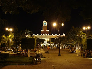
- The 'palacio municipal' or the town hall by night, built in 1836. In front, the main plaza,
- View of the plaza grande with in the background the cathedral of San Ildefonso. Considered like the first cathedral de America, the monument was built from mid to end of the sixteenth century,
- On the right of the cathedral, a narrow street was the place of an exposition of abstract art from a Mexican artist. Well for being abstract, this art was absolutely out of our knowledge of art and we had lot of problem to understand the name of the statue and its representation,
- Again, a cat. After the shy cat we gave food in playa Del Carmen, this was the cat of the hostel and her name was Mirela and she was not shy at all. She followed us in our room and started to read the guide book. Well not sure she liked it because after 5secondes, she turned her head. She had her proper chair in the lounge of the hostel with her photo stuck on the table,
- Lee tried lots of sunglasses and spent a long time to decide the model he wanted. But he liked his pair of fake RayBan bought in Cartagena {Colombia} and wanted to find similar model but without success. There were some original RayBan but out of his budget. So at the end I started to take pictures with the different pairs of sunglasses so he could compare all the models. The employees of the shop were amazed and found us a little weird. Telling them that finding the right pair of sunglasses was very important was not so easy especially for a man.

Playa del Carmen - photos


Playa Del Carmen:

Well, when we reached Tulum, it was the beginning of the influenza epidemic. We followed the news by internet and that was not looking too good. Our first intention was to head off to Merida after Tulum but by precaution, in case of the situation worsened, we decided to move to Playa Del Carmen, 45min from Cancun Airport but far enough from Cancun to avoid the crowd of tourists.

When we arrived to Playa Del Carmen, there were some tourists. When we left the town was quasi deserted. Lots of tourists had taken a plane earlier than planned and lots of them had canceled flights. For us, we stayed in a nice hostel close to the beach, following the news and reassuring our parents that everything was alright and that the epidemic was not as bad as people were thinking at the beginning. Also in the Yucatan peninsula, no case of flu was detected. So after a week of farniente {white sand beach, playing cards, siesta...}, we decided to carry on our trip and we headed off to Merida.

- Playa Del Carmen is a touristic destination but less crowded than Cancun. A part of the coast is covered by hotel resorts like this one in the picture,

- But we stayed in the town centre where the beach was quite empty and mostly used by locals,

- These pelicans were carefully looking at the sea for some food. Very impressive to see them diving at a good speed in the sea to catch fish!!

- While we were staying at the hostel, this cat was visiting us every night just for diner time!! It was very shy, a little wild too. It would not approach us except if we were at 1m from it,

- But tempted by some nice food, I could take this close picture. It didn´t look very happy!

Saturday, 23 May 2009

Tulum (Mexico) - photos 2


Tulum - Mayan ruins


The Tulum ruins are the third most visited archaeological site in Mexico, especially due to its location close to Cancun (2hrs South). The name is coming from the walls surrounding the site (tulum = wall in Yucatec Mayan) which were protecting the Tulum fort against invasion. The architecture of the site is resembling the Chitzen Itza ruins but Tulum is much smaller.

The city was first mentioned at the beginning of the 16th Century but was first described by an American explorer mid-19th century. It has been determined that Tulum was occupied by the late post-classic period (around AD 1200). The site continued to be occupied until contact with the Spanish was made in the early 16th century with the site being abandoned completely by the end of the 16th century.


The pictures represent views of the ruins. The main temple is situated on the cliffs. None of the buildings could be visited inside or we could not walk around. The colour of the sea was amazing, this turquoise is superb. We spent here a couple of hours, enjoying the views and taking iguanas in pictures. There were dozens of them in the site and lot of them were sunbathing in front of the sea! Not a bad life for them!!!

Tulum (Mexico)- photos 1


Tulum (Mexico):

We arrived in Tulum after a bus journey from Belize City via Chetumal. Here we decided to stay in the town centre and not to move in a hotel close to the beach because there was no collectivo service between the centre and the beach (only taxi charging quite a lot of money) and because of the price will be more exp
ensive.

First thing I did prior to visiting Tulum was to buy a new camera. Lee's camera takes nice pictures {and Lee too} but it is too complicated for me so I needed absolutely a new one if I wanted to continue to write this blog. Lucky, I found a Sony camera similar to my broken one. Now we were ready to see Tulum and its surroundings!

We rented bikes and went for a swim in the cenotes or underwater caves. Here we can swim, snorkle or dive. Then we went to visit the Mayan ruins, probably the closest ruins to the beach. Colours of the water were amazing as you will see on the pictures. Then before returning to town we stopped to the beach for a swim. It was 35C and we were all sweaty!!!

- Cenote Calavera. It is like a big hole...
- ...in which Lee was having a swim. He borrowed equi
pment for snorkling from a couple of Canadians and explored
the cave which had a very clear water,
- The beach, su
p
erb turquoise water and white sand. Also not crowded, very nice,
-
Very relaxing atmosp
here on the beach,
- There were iguanas everywhere here. And they were easy to take in
picture a little used too probably. This one gave me its better smile!

Thursday, 21 May 2009

Belize City - photos


Belize City:

From Placencia, we took a bus for Belize City which used to be the capital of Belize. After the hurricane which devastated the city in 1961, the governement (in 1970) decided to move all the institutions to Belmopan, close to the Guatemalan frontier. We passed by Belmopan in the bus and there was absolutly no charm and nothing here except concrete block buildings.

Well there was no charm either in Belize City. Obviously due to the hurricanes, the town is made now by concrete block buildings. Only few colonial buildings remained. It was also raining all the afternoons so after some walk during the morning, siesta, reading and cards for the afternoon! And what a pain to call my mum! The only telecommunications company which is also the only internet supplier has banned people to download and use Skype. The Belizian government has told the company to lift the ban but nothing has been done! So I needed to use normal phone but the office of the company was closed on a Saturday! Finally we found a shop selling cards to phone and I get only 6 min as the coast was 4 quid! Well after that, it was time to leave Belize for Mexico...the epidemic of influenza was beginning...

- The Belize river and the famous Swing bridge. Built in 1923 in Liverpool, the bridge is the only manually operated swing bridge in the world,
- View of the Fort George area which is the touristic place of Belize City,
- Drugstore close to the market place,
- The market place and its colourful benches. In the background the Highcourt building,
- How difficult was it to call my mum! That was a long time since Argentina that I had not used the public phone!

Placencia (Belize) - photos


Placencia (Belize):
From Rio Dulce, we took the boat to Livingston a small town on the edge of the lake Izabal. Here, we waited a couple of days for the ferry to leave for Belize. It was very humid and hot with lots of mosquitos! We spent our time reading and playing cards as nothing to do here. No picture either as nothing to see!

From Livingston, the journey on the ferry took 1hr and was not too bad. Obviously, I did not get any breakfast prior to leaving! But the sea was pretty calm.
We arrived at Punta Gorda, South of Belize and what a surprise to hear english!! Due to the fact that Belize is a former British colony, English is the official language. Even Lee had some issue switching back to his mother tongue! Well, it was not so easy to understand them because they are talking a mix between creole and english and also the Garifuna.

From Punta Gorda, we took the bus to Independence then a small boat for Placencia, a small village on the Carribean coast. In Belize, we will stop only in Placencia and Belize City because things are very expensive here. There are nice cayes and nice Mayan ruins on the West but we could not afford to stay too long.

In Placencia it was very cloudy and windy and we had some rain during the afternoon. Not the idyllic holidays! Lee spent most of his time fishing and caught 3 medium size yellow tail snappers. We had them for diner, very nice! And it was nice to have our own kitchen for 3 days because we could cook nice home dishes and without the trouble to have other persons messing around! Still no camera for me so all the pictures taken in Belize are from Lee.
- Sunrise on the Carribean Sea. Very cloudy already...
- Early afternoon, the sky was getting more cloudy and rain was very close,
- Lee was happy to catch some fish. This one was too small to be eaten but he caught 3 decent size yellow tail snappers...
- ...which I prepared in the French way...sliced onion, sliced lemon, sliced tomato, sliced mushrooms, a little of oil et voila! Bon appetit!

Wednesday, 13 May 2009

Rio Dulce - photos


Rio Dulce or where I broke my camera (with Lee's help!):

From El Remate, we had two options: heading directly to Belize via Melchor de Mencas or heading east and crossing the frontier via Livingston. Even if the second option was more expensive, we choose to go to Rio Dulce then Livingston as that would be our last opportunity to take the boat.

From Santa Elena, we took a direct bus to Rio Dulce and found a nice hostel on the bank of the Izabal Lake.
Lee was happy as he caught lots of fishes just on bread. As we did not have access to the kitchen, we asked the chef if she could bake some fishes for us. She joined us on the wood pier and was amazed to see all these fishes. She said that was exceptional because normally locals catch few and small fishes. At the end of the afternoon, we had a big bag full of different fishes and in particular the locals' favorite, the "mojarra". The chef gave some to a neighbour family and kept the rest for the lunch next day. The next day, when with the owner of the hostel we came back from town for lunch, the fishes have gone!!! The cooker shared them between the gardeners, the cleaners and other people!!! Lee saved in-extremis a piece for me but the owner and himself did not get any!!! We were not happy at all because even if there were lot of fishes and enough for everybody, the courtesy was to first give some to the fisherman then to dispatch to the rest of people. Later, the owner recognised that has been very impolite from the chef as he wanted to taste some fish too. Lee tried to catch more fish this evening but the good fortune has gone and only 5 fishes were in the basket! Personally, without putting in doubt Lee's talent for fishing, I think that was exceptional to have all these fishes on the same place! Lee says it was his genius.....

The same day, I broke my camera. Well my camera was on the edge of my chair and when Lee tried to get through the way, he kicked the camera with his elbow. The camera fell on the floor and the lens did not work anymore. I had this camera for 2 years and all along our trip. Well I will have to find a new one!

From Rio Dulce, we took the boat to reach Livingston. The trip was supposed to last 2hrs but we reached Livingston in 1hr, stopping very quickly in some sites where we were supposed to stay longer...but the scenery was superb!

- The bank of the Izabal Lake close to our hostel. Lee was fishing from a similar wood pier...
-...and lucky, he caught lot of fishes like this long silver one (whose name I have forgotten!)...
- or like this "mojarra", a bony and spiky fish but with a very tasty meat. At the end of the afternoon, there were at least 20 fishes in the bag!
- How cute is she!! This female dog stayed with us during the fishing having one's eye on the pieces of bread that Lee was using for fishing. She was very affectionate,
- From here, my camera broken, I asked Lee to take some pictures for me. This photo was taken during the cruise to join Livingston. As I said previously, superb scenery, everything was green, from the water to the trees!,
- View of "el Castillo de San Felipe" or the "castle of San Felipe". This fortress was built in 1652 to keep pirates away from the villages. After being burned by some pirates and left in ruins, the castle was reconstructed in 1956,
- One of the point of interest during our cruise was the lily pad carpet but as this time of the year, there was not many!!!

Tikal - photos 2


Tikal:

- View of the Temple II from the main plaza. You can distinguish on the left of the pyramid some stairs. Well, encouraged by Lee, I went up and the view from the platform (just in front of the door) was superb. From here, I took the 2 next pictures. That done, going down was more traumatic and took me long time...but I did it and I was happy!
- View of the main plaza and the Temple I or the Temple of the Great Jaguar. Climbing this Temple was permitted some time ago but due to some deaths of tourists (the stairs are very steep and the stones not very well straight) it is now not possible to climb,
- View of the North Acropolis,
- Lost World Pyramid, 30m high, a true pyramid with stairways in 3 sides,
- Main of the trails were crossing the tropical forest and Lee could not abstain to play with the vines like Tarzan!

Tikal - photos 1


Tikal ruins:

From El Remate, we took a collectivo at 5.20am to be on site by 6am for the sunrise over the ruins. Unfortunately, it was very cloudy and only a couple of sun rays were filtering through the clouds but it was also nice. Then we spent the day walking in the ruins which were surrounded by tropical forest and having a kip mid-morning as we were tired (we woke up at 4.45am!). Very very impressive!!!

Some history about Tikal:
Tikal is one of the largest archeological sites of the Maya civilization situated in the Peten region. In 1979, it was declared Unesco world heritage site. Tikal was one of the major mayan cultural and population centers, dominating in all domains the Maya region during 200 to 900AD (called the Classic Period). Due to many wars with other Maya states, the site declined and by the end of the 10th Century it was abandoned but the knowledge of the site was never completely lost...in the 19th Century, Stephens an American explorer reported the existence of a "lost city" and mid-19th Century, the site was visited the first time by explorers Mendez and Tut.

- View of the front summit of the Temple I and the back summit of the Temple II (left); view of the back summit of Temple V. This picture, and the next one, were taken from Temple IV, 70m high (or 230 feet). It was around 6.45am when we reached Temple IV which is the Northern of the Temple (see photo of the site). Grey sky with lots of clouds...
- Summit of the lost world Pyramid, 30m high,
- Map of Tikal site. Schematically, the trails have a form like a bird. On the top end, it is Temple IV, at the end of the left wing, Temple VI. The main plaza with Temple I and II is situated at the face of the bird,
- Temple V,
- A system of stairs allowed visitors to reach the summit of the Temple. Lee, who does not suffer from altitude sickness, went up. We can distinguish him in the middle of the stairs system (with a red top and a black bag). I was waiting at the bottom of the pyramid. No, it is not because I am not comfortable with the altitude, somebody needed to stay down to take the pictures!!!